Friday 17 February 2017

South Africa Sojourn Wilderness in a nutshell and the end of the road

Rather than covering a day in some detail, I will try to give a flavour of the various activities that we did whilst we were staying in this beautiful area. This is because I am still having technical problems uploading pictures from the camera to my tablet.


This is the village of Wilderness as viewed from dolphin point. The beach is wonderful sand and great to walk on or sunbathe but a strong undertow makes swimming a risky activity.
There are however loads of other activities on offer so I thought I'd give some of them a go.


Getting up on board is a bit of challenge, but once you have cracked it, it's great fun.


The paragliding is more a case of just jumping off the cliff face and hoping you land in the water, watching out for that undertow of course. The helmet is a great reassurance as you would expect.


 Driving the steam engine was a special treat and of course my experience in Copenhagen was a great help.


 Senor Diaz's little ship badly needed a run out. 500 years in dry dock is far too long. Thanks again to Helen for her excellent photography to record all these fun activities.


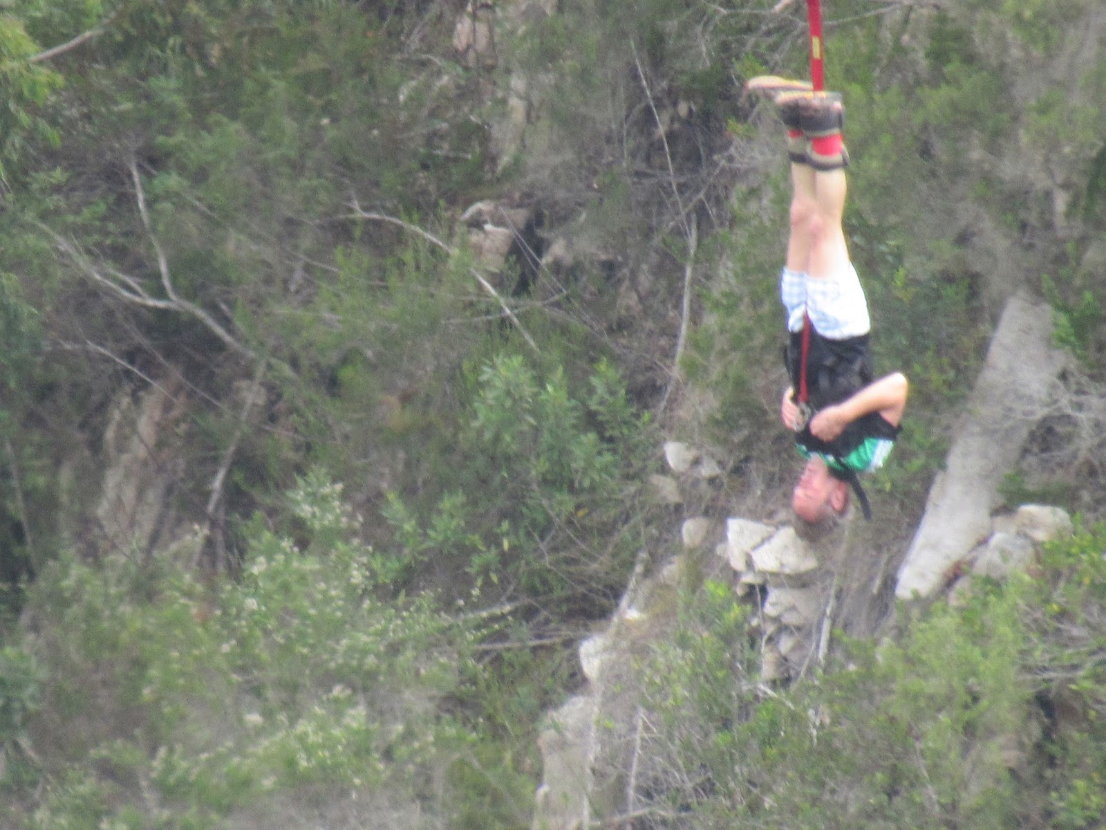
Then there was the bungee jump. Not surprisingly I seemed to have lost a bit of weight as well as my hat doing this. Aficionados of this activity will recognise the site as the Bloukrans Bridge which offers a jump of 216ms which is the highest in the world for a bridge jump. In case you don't believe me, yes Helen did take this photo.


This is the full view of the bridge. You jump off the centre point of the concrete supporting arch. If you look carefully you can see the people getting ready to jump and if you look very, very carefully you might just recognise me, but don't worry too much if you can't.


We had a great day out going east down the Garden Route to Knysna. The town is built on the exquisitely beautiful lagoon and surrounded by ancient forests of yellowwood and stinkwood. The lagoon enters the sea between two narrow sandstone cliffs called the Heads which you can see in the picture above. This harbour entrance was proclaimed by the British Royal Navy to be the most dangerous harbour entry in the world.


One of the best ways of seeing the cliffs is by boat. I really can't believe that anybody that knows anything about nautical terminology can call their really rather pretty boat "Heads"!


This is looking back at the lagoon and the town which is now a popular tourist location with holiday homes and marinas. The logging industry is still working but sadly not the railway.


A few kilometers west of Wilderness is Victoria Bay. You can see what the priority is here and it is about the best venue for surfing on the entire Garden Route having the most consistent breaks. For the technically minded it's perfect when the swell is about 1-2ms and you get a great right-hander.


Eschewing the delights of surfing, this little fellow who is about brick sized much prefers sunbathing


Above and below some of the spectacular flora in Victoria Bay. The Bay was developed with a few cottages, a pier and a small tidal swimming pool in the 1920s by a bloke who won a very substantial sum of money with a ticket for a sweepstake on a horserace. He offered a share of his winnings to the Dutch Reform Church but they turned it down as it was the proceeds from gambling. The Methodists however accepted it on the basis that life is a gamble!


The original cottages are looking a lot more up market now.


The Montagu pass was completed in 1848 and was another road built by convict labour. It has the distinction of being the oldest unaltered pass still in use in South Africa. Not so scary as the Swartberg but impressive nontheless with some magnificent mountainous and sylvan views.


So the time has come to say good bye to Karen and the beautiful Fynbos Garden Suite and we must head east on the N2 to Port Elizabeth where we are over-nighting prior to our flight the next morning from PE to J'boug. Our only intended drop off, as it were, is the Bloukrans Bridge with the famous bungee jump opportunity. This is indeed what we did, as mentioned previously. By late afternoon we reached PE and booked into Lavender Terrace B&B.


As you can see the lavender gets in everywhere plus I think I can spot a wee glass of complimentary sherry. This place has a whopping booking.com rating of 9.6. Ginny the landlady is terribly obliging but the whole place is really rather twee for my taste but my Auntie Cissy would have loved it (but then she did have a musical toilet paper dispenser). Talking of toilet paper the theme continues in the bathroom, as you can see below.


Ginny served up a lovely breakfast, garnished with lavender, of course (I kid you not). Next morning we returned the car and made the flight to J'boug without incident. That gave us about eight hours to hang about the airport until the flight departed for London. Do you know what, we nearly missed the flight! Hey ho, story of my life. When you read of my funeral, would you mind turning up the next day?
Well that's it for South Africa for now, but I can't close without a couple of credits. Firstly to my Helen for her company and fortitude under the most trying of circumstances, secondly to Cameron who was there at inception, execution and conclusion. He, Finlay and Olly met us at Peterborough station with a fulsome greeting and a ride home.

Saturday 11 February 2017

South Africa Sojourn Prince Albert and the scariest Pass in the world

Karen, our host suggested to us that we might enjoy a day out driving which would involve visiting Prince Albert and attempting the Swartzburg Pass challenge. She thought out "little car" might be up to it. Not being ones to decline a challenge we gave it a go.
Firstly we went to George, which is a transport hub and has a rather good railway museum with a dozen locomotives pensioned off. There is also a variety of old rolling stock including a carriage used by the British royal family in the 1940s.


This was the most active bit of the railway system east of Cape Town, and you can see how active it is! I thought the no smoking sign especially appropriate.
We headed north out of George and immediately started to climb the Outeniqua pass which takes us over the mountains of the same name. This is the range that you can see from our accommodation. The road is a major and well surfaced.


This road takes us to the only largish town we will pass through, Oudtshoorn and its raison d'etre now is the ostrich. They farm them, let you ride them, eat them, tan their leather and make lots of things from it, use their feathers (boa anybody?). I couldn't see a use for their beaks but I must have missed something.


Apparently their brain to body ratio is extremely low so the head in the sand story is probably true.
We motor on north to De Rust. There we stop for a coffee at the excellent Ray's Coffee shop. We have it iced as the temperature is now climbing into the 30s. Onwards and upwards towards the Meiringspoort Pass. This pass takes us out of the Little Karoo into the Great Karoo (see blog entitled in the shadow of the Blue Train for details of the Karoo).


      Meiringspoort pass, just a bit reminiscent of the gorges of Crete.


This baboon had just nipped through the baboon proof fence to get a closer look at the road.

Having conquered this pass the way is now open to us to Prince Albert.
Prince Albert was founded as Albertburg in 1765 and renamed Prince Albert in 1842 in honour of Victoria's consort. The town is very Afrikaan and Dutch architecturally. It is now gaining a considerable reputation as a foodie centre, successfully growing fruit, thanks to the run off water from the surrounding mountains.


                           The Dutch Reform (and only) Church


On the surface a little Art Deco gem, but I suspect that it's a pastiche and if so who built it? There is nothing anything like it in this little town.
The temperature is now approaching the high 30s and it is time to make our attempt on the "scariest pass in the world".
Firstly a little history of the Swartberg Pass. I will quote from the South African mountain passes web site. "The Swartberg Pass is for many
South Africans the rubicon of gravel road passes. There is an allure and a mystic around this old pass coupled with its status as a National Monument which elevates this pass to the very top of the list. It was Thomas Bains final and best piece of road building. "
It was constructed between 1883 and 1886 with the assistance of 250 convict labourers. At the start of the climb you frankly wonder where on earth the road is going to go. You appear to have just a mass of rock cliff in front of you. There must be a tunnel, you think but of course there isn't, just a very steep gravel and sand track. There is also no form of safety barrier whatsoever. I took most of the incline in first gear .


Journey into the centre of the earth. 

Bains was a  very experienced road builder, as was his father and the key to his success was his use of interlocking dry stone walling to support and build up the hair pin bends. 


Looking back on the 12km climb. 


And some more 

Bains gave the various stages imaginative names for example, Skelmdraai (devious corner), but his imagination rather ran out at the summit which he named Die Top. 


Here we are. People like to leave their mark rather like your flag at the top of Everest. The view of the other side is totally different but no less impressive. We now have an aeroplane view of the Little Karoo. 


The pass is known as the "scariest pass in the world" and whereas there might be scarier in darkest Afghanistan, this one with its steepness, loose and uneven surface and complete lack of safety barriers lived up to its sobriquet for us. We have one more mountain pass to negotiate before we reach Oudtshoorn again. This is called the Schoemanspoort Pass, which after our recent experience is a walk in the park. When we eventually get back to our base the sun is still bright and hot so we enjoy a little while bathing in the sun and the pool. 

Friday 10 February 2017

South Africa Sojourn Go east! to Wilderness

The route from Cape Town to Wilderness involves following the N2 for 450 km. Without stopping it is a four and a half to five hours drive. It is not a motorway, indeed not much of it is dual carriageway but it is well laned with two up and one down on undulations and there is a hard shoulder most of the time into which slower vehicles will move to assist overtaking. Most drivers are very polite using a double flasher thank you which is responded to with a headlight flash. Maximum speed is 120kms per hour but this is frequently dropped to 100 or 80 kph. at junctions or by-passes of towns. It is an enjoyable and fairly relaxing drive
We fuelled up and coffeed just outside Cape Town then didn't stop again until the only robots (traffic lights) on the entire route at Somerset West. What is a nuisance for drivers becomes an opportunity for these enterprising young men.


One of the roadside vendors with his portable shop. They were friendly and polite but not pushy.
Other drivers were not so lucky with either the fuel fairy or their mechanicals.


                                   I'm afraid we didn't stop to offer help.

As we drove east we had a continuous series of mountain ranges to our left (north) with the land falling away south towards the Indian Ocean although this was rarely in view.


                                              A wee bit hazy I'm afraid

                        Typical of South African roads, long and straight
The journey continued without incident until just after Swellendam, about three hours in, when we witnessed what was a horrific crash. The car two ahead of us veered to the left and struck the start of the the crash barrier which launched it into the air, at the same time twisting the vehicle so that it first landed on its roof. It bounced up again twisted another 180 degrees eventually landing on its wheels again. The car immediately in front of us stopped about 200ms past the crash and remained there with its flashers on. Meanwhile we stopped about 100ms beyond,  so I reversed back with flashers on anticipating having to deal with some serious injuries. As we got out to approach the battered car two young girls emerged, one after the other apparently unhurt. Within seconds of us talking to the girls a police car stopped behind us and three police officers got out. Within less than a minute a car on the opposite side of the road stopped and the passengers crossed over to join us. These transpired to be one of the girls parents. How on earth everybody arrived almost immediately completely beats me. When Helen asked one of the girls what happened she said that she didn't know because she was asleep. I suspect that they both were. There seemed no point in us hanging about as the police didn't seem to want statements, so we went on our way. Within five minutes we had seen three police cars and two ambulances speeding towards us blue lighting their way to the accident.
Just a little shaken, we decided to stop for lunch at a roadside cafe called the Blue Crane which was really nice. Now we are approaching the coast and get our first view of Mossel Bay.


As well as being the start of the Garden Route,  Mossel Bay is important as natural gas was discovered in 1969 and it is now home to a large gas to liquid refinery run by PetroSA.

We are now just a short ride from our accommodation in Wilderness and we arrive at ten past five to be greeted by our host Karen. She lives in a beautiful house which sits on the crown of the valley of the River Touw. Her land stretches down the steep hill to the river below. The garden is her pride and joy. She, and her late husband cleared the land of any alien plants thus allowing a huge variety of indigenous plants to flourish again.  Not only is the garden a paradise but it is also a sanctuary for the local fauna, especially the bird life, but more of that later. Have a look at our garden suite.


                                                            Inside and out


I'm afraid that these photos don't do any justice to the house or the surroundings. You can however get a good view of the swimming pool that I used every day. Just one more look at the view from the terrace.


Monday 6 February 2017

South Africa Sojourn going to the place where two Oceans meet.

Destination the Cape of Good Hope. This was named not by the Dutch but by the Portuguese who sailed round it on their way to India and the Far East beyond. A strong Ottoman Empire had restricted the supply of spices and silks via the overland Silk Road. This was the motivation for the Portuguese to find a sea route to the East. So we head out south on the M3 which leads us to the Indian Ocean coast at Muizenburg which is a pretty holiday resort and fishing port. Incidentally the British landed here after Cape Town was ceded to them following their Naval defeat of the Dutch in 1814. Not quite that old, but still C 19 are the colourful bathing huts. Shades of Southwold.


Muizenburg beach huts. The railway serves Simonstown still a SA Naval base a little further down the coast.
We head down through St James, Kalk Bay and Simonstown to Boulder. This aptly named (there are huge boulders scattered around) village is world famous for its colony of the endangered African Penguins.


 There are only about two thousand in this semi urban colony.


They look cute, but don't try to get too close or that beak can give you a nasty peck.
Carrying on south, the scenery is spectacular. We are going down the east side of the Cape and so the sea that you are looking at is the Indian Ocean.


The Cape of Good Hope is not, of course the southernmost point of Africa (that is Cape Agulhas, about 180kms further east) but it is where sailors "turn the corner" and where the Atlantic and Indian Oceans meet. The final 12kms are through a National Park where the environment is carefully protected for all who live there. 


I think this probably means be careful not to get run over by a turtle, but I can't find it in the highway code. 


                                         This is the end of the cape


and now we are very close to it. 

There is a lighthouse now at Diaz Point that replaces the one in this picture. It was built too high up and was invisible for nearly half of the year because of low cloud. 


The day of our visit was a sunny Sunday so the area was quite busy. The Cape of Good Hope has something in common with the Rock of Gibraltar. There it is Barbary Apes here it is Cape Baboons. There are notices all over the place reminding people that baboons are wild animals and dangerous. Do not feed them. Helen saw one rush up to a girl and steal her bag, as quick as a flash. They have developed a taste for seafood and are becoming dependent on humans for feeding to such an extent that their survival is now threatened. 
Spot the difference 


                                                      Atlantic Ocean


Indian  Ocean 

We head back this time going up the west side, so you can see the Atlantic breakers. There were surfers making exciting use of them. 


But not in this picture! 
So finishes our last day based in Cape Town. Tomorrow brings a 5 hour drive on the N2 east to Wilderness and what I hope will be a very relaxing and enjoyable week at the Fynbos Garden Suite.