Wednesday, 16 January 2019

A Costa Rican Recce Sunday and Monday 13/14 January

Over the next two days we will explore San Jose. I will combine the days together to create a single blog. There's a bus stop just down the road from our hotel. The route runs down past the stadium round it and back up to the centre of the city on the other side the park. The city centre stop is dead opposite the National Theatre which is our first port of call. It is the only building with any real pretension of architectural importance and was constructed at the end of the 19th century. There must be a dearth of Spanish composers because a statue of Beethoven has pride of place on the facade of the building.


The composer of European national anthem is standing second window in from the left. They run guided tours in English each hour and it was great fun.


The floor under the stalls can be raised to create one large room which can be used for state celebrations when important visitors are entertained.


Dead centre of the stage and one tier up is the Presidential box. We were not allowed in,  but could view from the box next door and the chair that's roped off in gold is his. I don't think there have ever been any "apart from that, how did you enjoy the opera Mrs Lincoln?" incidents here.
The magnificent foyer is above the grand entrance and has a couple of interesting features. Firstly there are male and female withdrawing rooms where the men can talk about business, politics, religion and sex and the woman can talk about sex and everything else. Secondly there's a figure painted on the foyer ceiling in the panel representing day that appears to follow you as you move around the room. I don't mean just the eyes (Mona Lisa style) but the whole pose. Try it yourself. If it doesn't work for you, you will just have to go there or take my word for it.


The National Museum is located in the old fortress of the city which saw action up to the end of the 1948 civil war. It was here that Jose Figueres Ferrer, the leader of the coup signed the new constitution and declared the end of the national army in 1949.


Not a lot is known of the Pre-Columbian indigenous people. They didn't construct large temples or create cities like the Aztecs or the Mayans. They did however make balls. The Diquis people created these stone spheres which are seen as the icons of Costa Rican culture. Nobody quite knows how or why, but here is one, in its own atrium in front of the museum.


 Not far from the museum we got the chance to meet up with an old friend. I am sure that you will recognise him, though why he is trying to dip Helen's handbag  I haven't a clue. I can't imagine what he is doing here in Costa Rica.


In the late C19 railways played a major role in the economic development of Costa Rican agricultural. Getting a railhead to the Caribbean port of Limon was of crucial importance for the export of coffee and bananas. It was completed at considerable cost in lives and money. The whole network has now almost completely disappeared apart from some suburban commuting and a few freight trains. Below is the original Caribbean station. We enjoyed a coffee there but not a train ride.


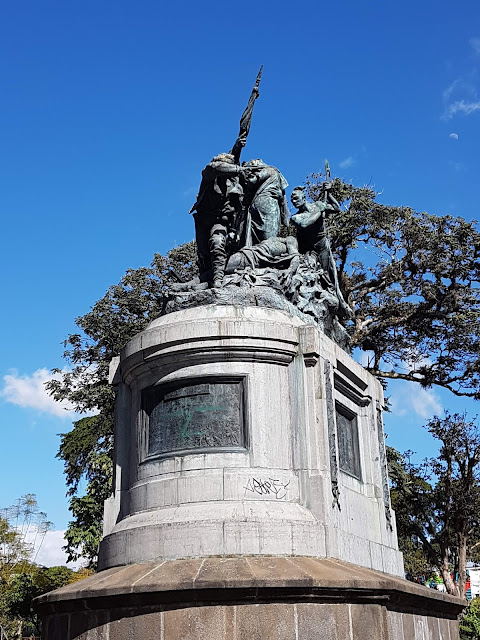
The National park is a large shadey sylvan space which contains some interesting statuary. Foremost amongst these is the memorial to the battle of Santa Rosa. In the middle of the C19, post Spanish colonial rule, there was a significant movement to create a United States of Central America. At the same time a small number of Americans were engaging in filibustering, that is trying to establish slave states in the existing Central American states. One such was William Walker who had inveigled himself into becoming the President of Nicaragua. The three other countries along with Costa Rica booted him out. The Hondurans executed him. So that is what this statue is all about. 


Most of the larger new buildings in the centre are banks. This one is clearly projecting its image at the common man (and woman).


This is its older headquarters in a rather splendid art deco edifice. 


Looking further down the street we can see the French baroque revival building but it could equally have been a corrugated iron single storey shed. Such is the nature of this city. 


This is the somewhat scruffy Central Park, more of a square really. The Lonely Planet guide book describes the bandstand as looking like it was designed by Mussolini. I see what they mean.


A much better bandstand this time at the centre of the Park Morazin. He was the Central American general who attempted to unite the separate states under one flag. The bandstand is the cultural symbol of San Hose.


The religious symbol of the city is the Metropolitan Cathedral as you can see below. Roman Catholicism is the major religious force in the country as you would expect given its Spanish heritage. 


Monday, 14 January 2019

A Costa Rican Recce Saturday 12th January

It's a long way to Costa Rica. A damn sight further than Tipperary. We left home at 3pm on Friday 11th, arriving at Heathrow just after 6 and with plenty of time to spare for our long flight to Mexico City.  The flight duration was 11 and a half hours. and we landed at 4.00 am local time. This bending of time works by winding our watches back 6 hours and after the four hour wait for the connection we had experienced a 21 hour long dark night. I suppose if you continue to fly west you could live forever in the dark.

The flight south to San Jose was a mear 3 hour hop and in delightful sunshine even though our take off was delayed by a furter unexplained hour. Have a look at some of the aerial shots of the west coast of Mexico, Guatemala, El Salvador, Nicaragua and Costa Rica. Don't ask me which is which, I'll guess.

My money is on Guatemala below


Now I think that we have reached El Salvador. A very straight coastline with some inland lagoons.


Some very rugged terrain which I reckon is Nicaragua zoomed in a bit.


Similar country without zoom but with the cotton wool clouds.


Here is the familiar welcome picture. I hope that it is self explanatory.


After a half hour bus journey into the city centre we took a taxi to our hotel which is situated on the edge of Sabana Park. Until 1955 this was the site of Costa Rica's international airport. The old terminal building is now an art gallery for local artists. The prestigious international football stadium  has also been constructed in the park.


Above is our hotel, if you look carefully you can see Helen waving from our room. Below you can see the iconic stadium somewhat silhouetted against the evening sunshine.


The park is heavily used for recreational physical activities, some casual, some organised and some, like the soccer below, a bit between the two. This activity resembles playground footy with about twenty a side. The formation looked like 7-8-7 to me.


Birds feature largely in the park, both the wild kind and some crafty re-creations from residual tree trunks. The bird below looks a little like a cross between a turkey and a big duck and is the warty faced Muscovy Duck.


These birds are everywhere. They are a very dark glossy midnight blue and gather in evening murmuration. Their keel-shaped tail is very distinctive. It is the Great-tailed Grackle.


The Scarlet Macaw. Unsurprisingly this one was not in the least bit shy as he is one of the tree trunk carvings.


You can hire a pedalo or, for the more ambitious, a horse or two.


And what have we here? So rugby is alive in Costa Rica, but sadly we didn't see any being played.


Tuesday, 18 December 2018

A Costa Rican Recce, the plan

January and early February will see us for the first time in Costa Rica, indeed this will be our first time in Central America so this blog is by way of an introduction to this increasingly popular tourist destination. The vast majority of visitors are either eco tourists in search of the wildlife or surfers in search of the waves. Nearly all of these come on pre organised packages. I have put this package together with a combination of research, guesswork and help from friends with local experience. Time will tell if the guesses are correct and the online local bus timetables are not works of fiction.

But first, meet Costa Rica. Named in Spanish meaning "rich coast", perhaps because indigenous people were spotted wearing gold or maybe as propaganda, a little like Greenland.  Christopher Columbus was responsible for the Spanish connection with his visit to the Eastern shores during his final journey of 1502. The territory was colonised by the conquistador Gil Gonzalez Davila who arrived via the West shore in 1522. It was always somewhat peripheral to the Spanish empire, perhaps because there were insufficient locals to create a decent slave workforce. The result was that it was largely unappreciated and overlooked by the Spanish monarchy. Perhaps this is one reason why it developed into a more egalitarian state than its neighbours.


You can see above a nice map of the country and its context in Central America. Although distances look modest,  journey times are lengthy due to the poor road infrastructure. Roads are not easy to build and maintain in a tropical rainforest.

Some more geopolitical facts; it has a population of about 5 million nearly half of whom live in or around the capital San Jose, it's known for its stable democracy and highly educated workforce, most of whom speak English. It spends 6.9% of its budget on education (cf world average of 4.4). In 1949 it abolished its standing army after a civil war and remains one of the world's few sovereign states without one.

Costa Rica performs consistently well in the UNESCO Human Development Index being placed 69th in the world, the highest of any Latin America country. It has impressive "green" credentials. It is the only country to meet all 5 of the UNDP criteria measuring environmental sustainability. New Economics Foundation identified it as the greenest country in the world in 2009. By 2016 98.1% of electricity was generated from green sources. It plans to be carbon neutral by 2021. Finally it has a higher proportion of its landmass designated as protected National Parkland (and sea) than any other country in the world. The diversity of its biosphere is immense. This is why you go to Costa Rica for the wildlife.

In order to follow the rest of this blog, you need to open the link below and you can follow the itinerary in more detail.

https://1drv.ms/x/s!Ar4ehnDjtvJGbWoMN6K7oFsF8c8


Saturday, 13 October 2018

A Cyprus Sandwich with a Lebanon filling Karpass peninsula

If Cyprus is an oblong frying pan, then the Karpass (Karpaz) peninsula is the pan handle pointing north east. Winston Churchill described the Karpass as a dagger pointed at the soft underbelly of Turkey. Whether you regard it as a threat or a refuge it is certainly a delightful area that time has largely left behind. Having now seen most of the areas of Northern Cyprus I have no doubt that this is my favourite. I like quiet all 80 kms of it. The biodiversity is brilliant with indigenous species being augmented by migrants many of which pitstop here whilst undertaking longer journeys.


Here's a typical view of the north coast at the start of the peninsula. There is a little tourist development but it is very low key and for the locals. Although a new road has improved access as yet it has had little impact on the lifestyle or development. Arable farming occupies the better land


One development that the new road has allowed is this brand new marina. There are berths for up to 300 yatchs and all the facilities you would expect from an international port of entry marina.


We enjoyed a tasty lunch at Hemingway's Restobar. Everything else was in place, the gym, chandlers, club house, ATM, repair dock, and swimming pool. The only snag was there wasn't really anybody else about.

We drove on up the peninsula through the little town of Dipkerpaz where the Greek and Turkish Cypriots live side by side. Indeed the mosque and the Orthodox church are next door to each other. Here below is probably the most famous and best beach on the whole peninsula. In its present state it is arguably the best beach on the Mediterranean. It is 3 kms long and you can see how busy it is.


 Meet the indigenous wild Cyprus donkeys. Like all animals in their position they have learned exactly where the food comes from and it's certainly not the sparse vegetation at their feet.

s
Inside the newly restored monastery of St Andrew. Well it has never really been a monastery, more a place of pilgrimage. There are several versions of the story but this is the most frequently repeated one. Andrew was sailing by, they had run out of water on board,  Andrew jumps ashore here, strikes a rock with his staff (as you do) and a fresh water spring bubbles up. They all have a good drink, fill up their water vessels and sail off to spread the word elsewhere. Fortunately the water has healing powers! Of course somebody had to let it out so now all the wretched pilgrims come. Whilst we were visiting, the priest and his lady friend were doing that chanting singing that they do. It was probably better than the kareoke we went to that evening.


The medieval chapel that marks the saints landing spot. There are lovely safe and sandy bays either side of this point where he could have made an easy landing, but I suppose he had to do the rock striking bit.


This is the outside of church we were in two pictures ago. Now somewhat over restored, the structure originates from the C19.


It is another 8 kms to the very end of the Karpass along a bumpy track, but worth every minute of the journey because when you get there you feel like you're at the end of the world. We are in fact just by Anne's right shoulder.


Just in case you weren't sure, this is the Turkish Republic of Northern Cyprus, with its own flag and the flag of the only other country that recognises its exsistence.


So that's goodnight from us and the end of this series of blogs from Cyprus and Lebanon.


Wednesday, 10 October 2018

A Cyprus Sandwich with a Lebanon filling 7th Oct Sidon and Tyre

South from Beirut today to visit the ancient cities of Sidon and Tyre. Conveniently it is 40 kms to Sidon and then another 40 kms on to Tyre. The route is down the coastal highway. This is a well paved though very busy road, not a motorway as we would understand but by Lebanese standards pretty good.
Sidon is Lebanon's third largest city and its name means fishing-town. You come off the highway and approach the town along the promenade fronted by a fine sandy beach as you can see below.


Here we are paying for parking and tickets to the castle, but look carefully at the two little messages of peace on the kiosk.


The castle is built on and from an old Phoenician temple on top of which is a Roman temple. Got that? Just to complicate the issue archeologists think that the whole lot was built on top of a palace.


This picture shows rather well the way that the Crusaders used the exsisting Roman columns. The local rock is a rather soft sandstone but by bracing it with the granite columns, the castle could resist not only attack but also several earthquakes over the centuries.


For those of you for whom the Book of Genesis has some relevance the following information may be of interest. Sidon was the first born son of Canaan, the son of Ham, thereby making Sidon the great grandson of Noah. Moving on to lower things, the souk area was across the road from the castle in the sea, so this was our next port of call. This was a fascinating market area both inside and out. Outside was mainly food, with butchers, fishmongers, fruit and vegetable stalls interspersed with car repair workshops. Inside you could buy clothing, jewellery, hats, shoes and pretty well anything else you can think of.


This elegant house is above the famous Soap museum. Beaten into third place by the Keswick Pencil museum and the Rekyjavik Penis museum for the world's most fascinating single subject museum, this place still manages to pull the punters in. It is based in a C17 soap factory although parts of the building date to the C13. The museum was set up by the Audi Foundation (Lebanese political and banking family, not the German car makers). Audi, a former President lived in the house in the picture. The museum has a mission of health education as well as to sell olive oil based soaps.


We didn't visit the St Louis land castle, which was built by French Crusaders in the C13, because it was closed for restoration. I do hope that they don't overdo this one.


We drove on towards Tyre. The highway ran out and we swung east on a rather inferior road. The numbers of military checkpoints seem to increase and the amount of political propaganda was proliferating. We have now entered Hezbollah controlled territory. Descrection being the better part of valour and the fact that we are heading towards the Isreali border influenced our decision to turn around and make for the coast again.
We eventually arrive in Tyre and park up near the harbour on the peninsula. See the photo above. Tyre is 12 miles from the modern border with Isreal and 25 miles from the Syrian border so we getting into a conflict zone.


On the harbour headland is the Maronite Catholic Church of Our Lady of the Sea where we enjoyed a shady walk around. On leaving the church we chanced to bump into another UK tourist. After a brief conversation he turned out to be Paul, the barista from the Tearoom in the Woods, Woodall Spa. Small world! Paul was travelling alone and had come down from Beirut that day on the dolmus. His friends from Woodhall didn't expect him to return either. Best of luck Paul, we'll look you up next time we are in Woodhall Spa.
The chapels that you are looking at above are built into the ruins discovered during excavations in the western courtyard of the church. The chapels are completely out of historical context. The stones you can see are from the Hellenistic period ie 300 to 400 BCE, well before the birth of Christ or the Maronite Church. I'm not sure what the church is up to building these chapels.


This is the west side of the peninsula with a small rocky swimming area. Tyre is another UNESCO world heritage site, mainly because of the superb Roman remains. There are also remains from the Phoenician, Greek and Crusader periods. Back to the Roman stuff, Tyre has the largest surviving hippodrome in the world and probably the second best overall remains, beaten only by Baalbek which is another Lebanese world heritage site.
Time unfortunately didn't allow us to see much of Tyre's Roman heritage and nothing at all of Baalbek.


The journey back to Beirut was more stop than start but we did eventually reach the hotel for our last night in Lebanon. A number of factors beyond our control conspired to delay our journey to the airport, return of the hire car, the checking in process and, the last straw, passport exit control. The end result was we missed our plane. We did however manage to book onto a Middle East Airlines flight which could take us out eight hours later. As of the present time we are still in dispute with Cyprus Airlines.

A Cyprus Sandwich with a Lebanon filling. Jeita grotto and Byblos 6 Oct

Today we will head north out of Beirut and try to visit two of Lebanon's significant tourist destinations. It might sound odd to say this but finding them will prove to be a challenge. The problem is that signage is almost non existent. I think the vast majority of them go by organized tours or taxi.
The first objective is the Jeita Grottoes. These are a limestone cave gallery system. The system was first discovered by the Western world in 1836 by an American missionary having a bit of downtime. In fact there is plenty of evidence of human habitation in prehistoric times. The cave system was in the top 14 finalists in the New 7 Wonders of Nature decided by poll in 2011.
There are two levels open to the public, an upper which you visit on foot and the lower where boats are used.
From the visitor centre there is a cable car to take you up to the first gallery. In their wisdom the organisers have banned all photography within the caves which makes promotion of the place by the visitors rather tricky. No flash I can understand, but this rule seems a little short sighted. The result is that these images you are looking at have been obtained by a rather nefarious route.


A pair of downloaded documents I'm afraid and both of the lower cavern. They are more colourful than we experienced, however the caves were undoubtedly very impressive.
At 8.2 meters the upper gallery claims to have "one of the longest stalactites in the world". As they reportly grow at the rate of between a quarter inch and an inch every century, let's do some maths on the biggy. 8.2 meters = 322.854 inches. Let's say 323 for the sake of simplicity and let's say it's growing nearer to the faster rate of three quarters of an inch per century, then to reach it's present size it will take 431 centuries or 43,100 years. All that was assuming a constant growth rate and I don't suppose it did but our three quarters inch average should iron out the variations. Conclusion, not long in geological time, I guess but I'm still pleased that we didn't take a hammer to one. Any geologists out there who want to comment?


We had one of those road train thingees to transport us down from upper to lower caverns.
The shot below gives a better idea of the colours. There's some colouration present due to the different salts in the water. This is the upper cave where a concrete pathway has been built in to improve visitor access.


The whole trip took a couple of hours and now it was time to head north to Byblos. Just before we reached Byblos we turned off the highway looking for a beach and lunch break. Serendipitously we found this little beach bar that suited our purpose very nicely.


Let me tell you a little of the background to Byblos, which is incidentally one of Lebanon's UNESCO world heritage sites.
It's recorded history goes back 7000 years, it was known as Gibal in Biblical times when the Canaanites traded from here. The Phoenicians inspired by Egyptian hieroglyphics invented the first phonetic 22 letter alphabet which was adopted by the Greeks in 800 BCE. This later became the foundation of the Roman alphabet. The name Byblos refers to the papyrus trade from this dock.


Surrounded by Roman debris.


Roman and Crusader ruins add to the picturesque nature of the view.


Beer festival on Roman street. I bet the Romans would have loved it.


Apart from the ancient archeological sites you can see, Phoenician, Greek, Roman, Crusader and Otterman ruins. There is a pretty little harbour with outside bars and restaurants and the old souk area is now selling souvenirs. Ironically there was a German beer festival taking place during our visit which was just warming up as we left. Now there was just the challenge of driving back to Beirut and finding the hotel again.